The Igneada Floodplain Forests—a flooded forest near the Black Sea on the border with Bulgaria
When, after a downpour, the water rises in the streams flowing down from the Strandzha Mountains, something happens in the lower groves between the lakes and dunes that you will hardly see anywhere else in Turkey: ash and alder trees literally stand knee-deep in the mirror-like water, and a person with a camera walks here as if through a flooded painting. This is the Igneada Floodplain Forests—a 3,155-hectare national park at the country’s northwesternmost tip, in the Kırklareli province of the Marmara region, near the Turkish-Bulgarian border. The park was established on November 13, 2007, and became Turkey’s 39th national park, uniting several previously separate natural areas. The Igneada floodplain forests are an ecosystem extremely rare for the Mediterranean basin, where marshes, dunes, lagoons, the Black Sea coast, and flooded riparian forests converge in a single location.
History and Origin of the Igneada Floodplain Forests
The geography of this area has been shaped over millennia. For centuries, streams have flowed from the foothills of the Strandzha mountain range (Yıldız Dağları in Turkish—the Star Mountains) down to the Black Sea coast, carrying humus and silt with them every year during the flood season. Thus, a wide floodplain emerged right at the shore, where alluvial terraces transformed into a rare type of forest that the Turks call longoz—a forest that periodically submerges under water. It was from these seasonal floods that what is now shown to tourists as one of Europe’s last relict floodplain forests grew.
The human history of the place is no less intriguing. Local residents trace the very name İğneada (İneada) back to the legendary İne Bey—an Ottoman bey who annexed these lands to the Turkish domain. According to legend, the settlement that grew up near his camp bore the name “İne,” which over time evolved into the current “İğneada.” This eponym has survived to this day and greets travelers on road signs long before they enter the village.
For a long time, these forests remained a half-forgotten corner of Eastern Thrace: there were neither large ancient cities nor medieval fortresses here to attract tourists, as found in other regions of Turkey. Instead, there was silence, fish, and firewood—which was enough for the small villages of Demirköy, Begendik, and İğneada itself. By the end of the 20th century, scientists had noted that the floodplain forests around the Çavuşdere stream were one of the last remaining areas where flora and fauna that had disappeared from the rest of Southeast Europe were still preserved.
On November 13, 2007, the areas with various protection statuses were merged into a single national park. From that moment on, the Directorate of Nature Conservation and National Parks (Doğa Koruma ve Milli Parklar Genel Müdürlüğü) under the Ministry of Environment and Forestry took over management of the territory, built a network of wooden boardwalks and observation decks, and turned the Igneada Floodplain Forests into one of Turkey’s lesser-known yet most atmospheric natural destinations.
The village of İğneada itself is located in the Demirköy district and, prior to the park’s designation, relied on modest summer tourism and fishing in the Black Sea. After 2007, a new role was added—that of an entry point to the national park: guesthouses opened, birdwatching guides appeared, and a small environmental education center began operating. However, a mass influx of tourists never materialized, and many trails remain deserted even on weekends.
Architecture and What to See
There is no “architecture” here in the usual sense—no facades, colonnades, or mosques. Instead, there is the architecture of nature: five lakes of varying nature and character, a ten-kilometer-long ribbon of dunes, the longoz forests themselves, and a narrow strip of Black Sea beach. The route through the park is usually designed as a loop or a chain of points that are easy to reach by car, each with a short 20–40-minute walk.
Lake Erikli is a lagoon cut off from the sea in summer
Erikli (Erikli Gölü) covers 43 hectares and is located north of the village. It is a lagoon: in winter and spring, it connects to the sea via a narrow channel, and in summer, when evaporation exceeds the inflow of water, it separates from the Black Sea and becomes an almost separate body of water. The shores are reed-lined, the water is clear, and at sunset, herons and waders flock here.
Lake Mert is the park’s main body of water
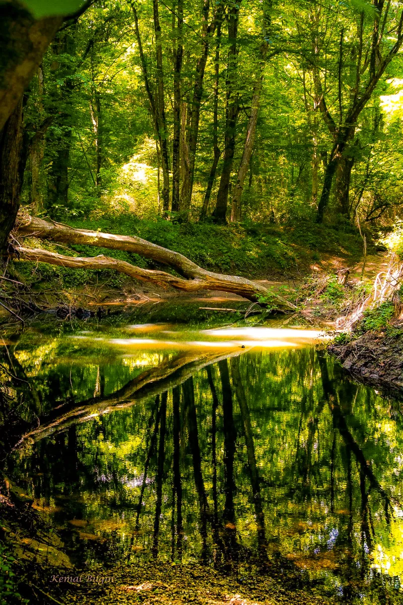
Lake Mert (Mert Gölü), covering an area of 266 hectares, is the park’s largest and most famous lake. It is formed at the mouth of the Çavuşdere stream and surrounded by a true floodplain forest of common ash, alder, oak, and beech. A wooden boardwalk with viewing platforms runs along the shore—it is from here that the most iconic postcard shots of Igneada are taken, where tree trunks are reflected in the mirror-like water.
Lake Saka and the Small Lakes—Hammam and Pedina
In the south of the park, between the longoz forest and the dunes, lies the small Lake Saka (Saka Gölü, just 5 hectares). It is separated from the sea by only a narrow strip of sand and often appears on lists of “Thrace’s quietest lakes.” A little further inland, one or two kilometers from the shore, lie two more small bodies of water: Hamam (Hamam Gölü, 19 ha) and Pedina (Pedina Gölü, 10 ha). These lakes are less accessible and therefore appealing to those seeking solitude and hoping to spot an otter or a black stork.
Dunes and Longoz Forest
A ten-kilometer-long strip of dunes divides the park into two natural zones. To the north, they stretch from Erikli to the village of Igneada itself; to the south, from the outlet of Lake Merta to the sea and the outskirts of Saka, in some places growing up to 50–60 meters wide. Endemic plant species, characteristic only of the southwestern Black Sea region, grow on the dunes; they are protected by an international agreement. And just a few hundred meters from the beach lies a floodplain forest: those very ash, oak, alder, and beech trees, entwined with vines and ivy, which literally stand in water at the height of the flood season.
The Black Sea Coast
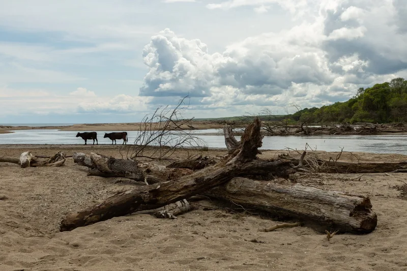
Beyond the dunes lies a deserted beach with dark sand and pebbles, almost entirely undeveloped. You can swim during the warmer months, but the currents here are strong, so you should swim with caution. However, the shore is ideal for walks and photography: waves, wet logs washed ashore by the storm, and in the distance—the Bulgarian border and the silhouette of the forested Strandzha hills.
The flora and fauna are what make the trip worthwhile
The forests are dominated by common ash (Fraxinus excelsior), oak (Quercus), alder (Alnus), beech (Fagaceae), and maple (Aceraceae); a distinctive feature remains the climbing plants—vines, ivy, and wild grapes—that entwine the trunks and create that “jungle” effect for which photographers travel to Igneada. The avifauna includes the white-tailed eagle, green woodpecker, gray heron, black stork, hoopoe, cuckoo, kingfisher, and owls. Among the mammals are the wildcat, wild boar, brown hare, pine marten, badger, Eurasian wolf, red deer, fox, and otter. In freshwater, trout, smelt, and mullet are caught, while in winter and summer, anchovies, horse mackerel, whiting, and flounder arrive from the Black Sea. Reptiles found here include the Balkan tortoise, Karelin’s newt, the asp viper, and the common grass snake.
Interesting Facts and Legends
- Local legends link the name İğneada to the Ottoman bey İne Bey, who annexed these lands to the Turkish domain; the name “İne” eventually evolved into “İğneada”—a rare instance where a Turkish place name preserves the memory of a specific person.
- The floodplain forests of İğneada are one of the last remaining examples of flooded broadleaf forests in Europe; in most European countries, such ecosystems disappeared as early as the 19th–20th centuries under the pressure of land reclamation.
- Among the park’s inhabitants are the white-tailed eagle (Haliaeetus albicilla), the black stork (Ciconia nigra), and the Eurasian otter (Lutra lutra)—three species that ornithologists consider indicators of a fully healthy freshwater ecosystem.
- In 2007, the Igneada Floodplain Forests became Turkey’s 39th national park—the status was granted to several adjacent protected areas combined into a single entity.
- Every summer, Lake Erikli “closes off” from the sea: the water level drops, a sandbar closes the entrance, and the lagoon turns into a separate lake until the autumn rains—local fishermen have adjusted their fishing calendar to this phenomenon for centuries.
How to get there
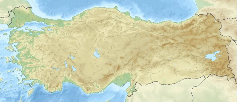
Igneada lies in the far northwestern corner of Turkey, in the Demirköy district of Kırklareli Province, near the border with Bulgaria. It is about 250 km from Istanbul and takes roughly three hours to reach. The most convenient option is by car: take the O-3 highway through Saray and Vize, then through Poyralı, Demirköy, and on to Igneada. From Edirne, the drive takes about two hours.
Without a car, you can take a bus from the Istanbul Bus Terminal (Otogar) to Kirklareli or directly to Demirköy, and from there, a local dolmuş to the village of Igneada. The route passes through Silivri, Çorlu, Lüleburgaz, and Pınarhisar. The journey is long (4–5 hours with transfers), and a car is still recommended for exploring the park on your own: points of interest within the park are spaced 5–10 kilometers apart, and there is no public transportation between the lakes.
An alternative is to join a weekend excursion from Istanbul: such tours are regularly organized by environmental clubs and tour operators during the high season. Admission to the park is free, but a nominal fee is charged for parking at some viewing platforms. If you’re traveling from Edirne (which is convenient if you’re combining your trip with a visit to Sinan’s mosques), the route goes through Kırklareli and Demirköy and takes about two hours in total; the road is scenic, passing through the forested foothills of the Strandzha Mountains.
Tips for travelers
The best time to visit is late spring (April–May) and early fall (September–October). In spring, the floodplain forest is partially submerged, the foliage is fresh, and the water level in the lakes is high—this is what creates the famous “mirror-like” shots. In the fall, the forest turns shades of copper and gold, and the weekend crowds have left. Summers here are hot and humid, and the biggest nuisance is mosquitoes: you can’t get by without repellent in the marshy areas.
Practical tips: bring waterproof shoes, especially in the off-season—the wooden walkways sometimes go right into the water; midge and mosquito repellent; binoculars for birdwatching; drinking water and snacks, because there are almost no cafes inside the park (a few simple establishments operate only in the village of Igneada). Swimming in the lakes is prohibited, and swimming at the Black Sea beach is at your own risk: there are no lifeguards, and the currents are treacherous.
Activities recommended by the park administration include photography, birdwatching, ecotourism, easy hiking trails through the forest and dunes, and picnics at specially equipped sites. The best months for birdwatching are the migration periods (late March–April and September), when flocks of storks and birds of prey fly over Strandzha. The local cuisine is seafood-based: on the coast, they serve fresh anchovies, horse mackerel, and flounder, either simply grilled or in the form of Thracian flatbreads, while in the forest villages, you’ll find homemade yogurt, white cheese, and cheese pie (a legacy of the Bulgarian borderlands).
For the Russian traveler, the floodplain forests of Igneada are an excellent alternative to Turkey’s usual “postcard” itineraries. While Cappadocia and Pamukkale have long since turned into a tourist conveyor belt, here the feeling of a real northern forest remains, somewhat reminiscent of the Russian floodplains of the Oka or Pripyat rivers in spring, only with Turkish place names and a view of the Black Sea. Set aside a full day for the park, spend the night in the village of Igneada at a small family-run guesthouse, and don’t try to cover everything in a couple of hours—the floodplain forests of Igneada reveal themselves in the silence, in the reflections of the tree trunks, and in the measured sound of the Black Sea surf beyond the dunes.